Weka Pass Rock Art
Loading...
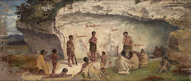
"Māori at the limestone shelter, Weka Pass" — Thomas Selby Cousins, commissioned by Julius Haast, Canterbury Museum, 1876. Canterbury Museum, NZ.
🏛️ The Discovery
Tucked into the hills of North Canterbury, New Zealand, lies a limestone overhang that has witnessed centuries of history. The Weka Pass Historic Reserve was officially established in 1969 — but the stories written on its walls stretch back far longer.
🎨 Ancient Canvas
Māori were the first to call this place home — even if only briefly. They visited seasonally for mahinga kai (food gathering), hunting moa, weka, kererū, and kākā. Under the limestone shelter, they rested by night and left their marks by day — using charcoal from fires and red ochre (kōkōwai) to depict human figures, fish, and dogs.
🔬 First Study
When European settlers arrived, they too sheltered under the overhang — and brought the drawings to wider attention. In 1876, Julius Haast, Director of Canterbury Museum, conducted the first scientific investigation. He commissioned artist Thomas Selby Cousins to copy the main figures and excavated the shelter floor, confirming Māori occupation between 600–1,000 years ago.
⚠️ The Conservation Tragedy
In 1929, at the direction of W.R.B. Oliver of the Dominion Museum, the original drawings were overpainted in red and black house paint to make them "more visible." It seemed reasonable at the time. In hindsight, it is regarded as a catastrophe — centuries-old natural pigments were buried forever beneath modern paint, irreversibly destroying their scientific and historic value.
🪨 Today
A fence now separates visitors from the drawings. The 40-minute walk across private farmland — closed 1 August to 1 October during lambing — offers time to absorb the weight of what we nearly lost. This 3D model captures what remains: the limestone overhang, the overpainted figures, and the story still unfolding.
*Closed 1 Aug – 1 Oct during lambing season. Dogs prohibited.